%20(942%20x%20204%20px).jpg)
Hiking to the Sofaïa Plane Wreck in Guadeloupe: Find the Hidden Wreck
- corentindutal
- Aug 28, 2024
- 3 min read

Updated: Apr 30
GPX track of the Sofaia plane hike (Sainte-Rose, Guadeloupe)
Guadeloupe is full of little-known hikes, and one of the most intriguing is the one leading to the Cessna wreck in Sofaïa, Sainte-Rose. Nestled in the heart of the tropical jungle, this hike offers a unique experience for nature lovers and adventurers.
Did you Know ? There are three crashed planes in Guadeloupe that can be seen, including the DC-3 that crashed on La Soufrière.
Sofaïa's Plane Hike in Photos


Practical Tips & FAQ
How long does this hike take?
The trail takes approximately 3 hours round trip, depending on your pace and trail conditions.
What is the difficulty level?
What equipment is recommended?
Can you swim along the trail?
Is this hike suitable for children?
What is the best time of year to do this hike?
Is there a risk of rising water levels?
What time should you start?
Elevation gain on this hike

Start of the hike
Discover the trail of the Sofaia Plane (Sainte-Rose)
Hike Starting Point
The trailhead is near the Sofaïa sulfur baths, a well-known site among locals and hikers. A parking area is available nearby, making it easy to start the hike in good conditions.
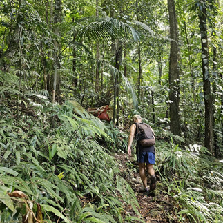
The trail quickly leads into a dense and humid forest, typical of the tropical climate in Basse-Terre. After a few minutes of walking, several forks appear. It is highly recommended to use a reliable GPX track to avoid getting lost.
On the Way to the Crashed Plane
With an elevation gain of 122 meters and a difficulty level rated between moderate and difficult, this hike is best suited for experienced hikers.
As you progress along the trail, you will cross several rivers, whose water levels vary depending on the season. Caution is advised, especially during the rainy season when rising waters can make some sections dangerous.
After about 1 hour and 30 minutes of hiking, the plane wreck appears, partially covered by vegetation. This crashed Cessna is now an unusual point of interest for history and adventure enthusiasts. The fuselage is still visible, though partially covered in moss and vines.
Along the way, you will be captivated by the rich local flora and fauna, typical of Guadeloupe. The hike reaches an altitude of 400 meters.
This demanding experience requires good preparation, including at least 1.5 liters of water, sturdy hiking shoes, and a mobile phone for safety.
Additional Points of Interest
Cascade des Trois Cornes: Located near the trail, this waterfall is a refreshing spot for a well-deserved break.
Tête Allègre: A summit offering an impressive panoramic view.
After completing the hike, you can relax in the sulfur waters of Sofaïa for a soothing experience.
For the more adventurous, you can continue the trail past the plane to reach Tête Allègre. From there, you have two options:
Turn left to return via Cascade des Trois Cornes (about a 5-hour hike in total).
Turn right to reach Tête Allègre viewpoint and loop back to the Sofaïa parking area (a long route, requiring endurance!).
Download the GPX Track
To ensure easy navigation and avoid difficulties, download the GPX track of the hike from our website. This will allow you to follow the exact route and safely reach the wreck.
.


Comentários