%20(942%20x%20204%20px).jpg)
Hike of the Tambour Waterfall - How to find it?
- corentindutal
- Aug 28, 2024
- 3 min read

Updated: Mar 26
GPX track of the Tambour waterfall hike (Petit-Bourg, Guadeloupe) to find it without getting lost.
Tambour Waterfall is accessible via a trail that leads to the Lézarde River, featuring uphill sections and technical passages. The route then follows the river upstream, requiring careful navigation at key junctions. Start from the area known as Diane, located in the heights above the Lézarde. The round-trip hike takes approximately 3 hours.
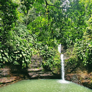
This is an aquatic hike with deep water crossings, so don’t forget to bring a waterproof bag! The waterfall is an impressive sight, and its natural pool is perfect for swimming, which is why we have included it in our Top 10 Hikes to do in Guadeloupe.
The Tambour Waterfall Hike in Photos


Practical Tips & FAQ
How long does the hike to Cascade Tambour take?
Expect around 3 hours for the round trip.
What is the difficulty level of this hike?
What should you bring?
Good hiking shoes
A rain jacket (K-way)
At least 1.5L of water
Snacks
A waterproof bag
A swimsuit
Weather & Safety
Can you swim at the waterfall?
Is the hike suitable for children?
Is the hike accessible to beginners?
When is the best time to go?
Is there a risk of rising water levels?
What is the best time to start the hike?
Elevation gain of Tambour Waterfall

Start of the hike
Discover the Tambour Waterfall Hike in Guadeloupe
The Cascade Tambour, located in Petit-Bourg, Guadeloupe, is a natural site accessible via a trail that first passes through the tropical forest before following the river upstream. This route leads to a waterfall fed by the Ravine Gras / Le Tambour River, where a natural pool offers the opportunity for swimming.
Description & Access
The starting point is at Diane. From Petit-Bourg, take the road leading to Hauteurs Lézarde, then turn towards Diane. A small parking area is available before beginning the hike.
The 1.88 km (one-way) trail takes approximately 1.5 hours to reach the waterfall. The path is unmarked but well-trodden, alternating between open sections and shaded forest trails. Two river crossings are required. The first is shallow, while the second can be deeper depending on the season and recent rainfall.
The trail includes some technical sections, requiring the use of hands to navigate rocky surfaces. The riverbanks are lined with dense vegetation, including ferns, heliconias, and large trees. Local wildlife such as birds and amphibians can sometimes be spotted along the way.
Cascade Tambour is an excellent destination for hiking and nature enthusiasts, offering a raw and preserved natural experience far from the bustle of civilization.
Practical Tips
Start Early: Begin the hike in the morning (around 7 AM) to avoid crowds.
Check the Weather: Avoid hiking after heavy rain, as river currents can be strong.
Equipment: Wear sturdy shoes for slippery rocks and bring a waterproof bag for river crossings.
Swimming: Bring a swimsuit to enjoy the natural pool at the waterfall’s base.
GPX Track
Want to explore safely? 📍 Download the GPX track for Cascade Tambour to follow the exact route and avoid getting lost.
.

Comentarios