%20(942%20x%20204%20px).jpg)
Soufrière Hike (Saint-Claude, Guadeloupe) - How to find it?
- corentindutal
- Jan 15
- 3 min read

Updated: Mar 11
GPX track of the hike to go to Soufrière without getting lost. This path is quite easy and well marked compared to other hikes in Guadeloupe. When you arrive at the parking lot of the yellow baths, the normal route is via the Pas du Roy. If you want to go faster, there is a road on the left that goes up to the old parking lot. This road is closed to traffic and probably to tourists as well. The GPX track takes you via this old road but if you have time, prefer the Pas du Roy which is nicer !
This hike is part of our exclusive pack: 16 must-see trails in Guadeloupe. Enjoy it!
The Soufrière Hike in Photos


How long ?
At night: Allow 1 hour to reach the summit if you are a good walker by the classic Pas du Roy - Savanne à Mulet - Chemin des Dames path. By day: With the many tourists, allow 1h30 to climb to the summit. You can also avoid the Chemin des Dames by going through the Col de l'échelle which goes around the Volcano. It is a little longer and slightly more difficult but much quieter in terms of the world.
Difficulty
AVERAGE
The climb itself is quite easy and the path is well marked. The difficulty is to arrive at the right time to see the Soufrière clear, which is quite rare (see below). Also watch out for the winds and the temperature at the summit, it's cold! And although there is a small bunker for shelter, bring a windbreaker!
What should be planned?
Good walking shoes A K-way (obligatory)
A bottle of water (minimum 1.5L)

Start of the hike
La Soufrière in Guadeloupe: Complete guide for a successful climb
Altitude and characteristics
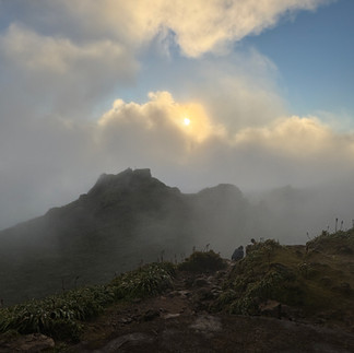
La Soufrière, culminating at 1,467 meters, is the highest point in Guadeloupe and the Lesser Antilles. Nicknamed "The Old Lady", this active volcano offers a unique experience between fumaroles, sulfur fields and lunar landscapes. The ascent is relatively accessible for hikers of all levels, provided you are well prepared.
The Soufrière tarantulas
As you climb, you might encounter one of the most surprising residents: the local tarantulas. Harmless to humans, they live in the wetlands and forests near the volcano. These spiders, although not very visible, play an important role in the Soufrière ecosystem by regulating insect populations. If you are lucky, you might spot one of these fascinating creatures on the Pas du Roy trail or in the Savane à Mulets.
How to maximize your chances of seeing Soufriere clear
La Soufrière is often shrouded in clouds, but here are some steps to maximize your chances of seeing a clear view:
Check local weather Consult the specific forecasts for La Soufrière on Météo France to assess today's conditions.
Analyze Wind and Clouds Head to Windguru to check winds and cloud cover. Choose a day with little to no low and mid-level clouds. A wind from the north or south is usually more favorable.
Observe cloud dynamics Use Windy to visualize cloud cover throughout the day. Clear skies at sunrise or sunset are often a good omen.
Cross-reference forecasts Consult multiple weather sources to refine your forecast. Keep in mind that these forecasts may be contradictory.
Observe recent trends If the summit was clear the day before, especially at sunset, your chances increase significantly.
These scans do not guarantee a clear view, but they increase your chances of fully enjoying the climb.
Practical details for the ascent
GPX Track : The GPX track we offer will guide you on an optimized route to avoid getting lost.
Parking and access : From the Bains Jaunes car park, the classic climb is via the Pas du Roy. For a quicker route, you can take the old road leading to the disused car park, although it is closed to traffic.
Duration : Allow around 1 hour to reach the summit if you walk at a good pace, or 1.5 hours during the day with lots of people.
Alternative routes : The Col de l'Échelle is a more leisurely option, although slightly longer.
Precautions : Bring a windbreaker to cope with the cold and gusts. The summit can be extremely windy.
By following these tips and carefully preparing your climb, you will be able to fully enjoy this unforgettable experience offered by Guadeloupe's emblematic volcano.
Download the GPX Track of the Hike
For those who wish to explore Soufrière independently, we offer a detailed GPX track of the hike, to be opened on an application such as maps.me
This hike is part of our exclusive pack: 16 must-see trails in Guadeloupe. Enjoy it!


Comments