%20(942%20x%20204%20px).jpg)
Hike to the Second Carbet Waterfall (Capesterre-Belle-Eau, Guadeloupe) - How to find it?
- corentindutal
- Jan 29
- 3 min read

Updated: Mar 11
GPS track of the hike to go to the Second Carbet Waterfall without getting lost. This route is very easy and accessible. The path is well laid out and it will only take you 15 to 20 minutes to reach the second Carbet Waterfall. Access to the Falls is payable upon arrival (around €5 per person). This money is donated to the Guadeloupe National Park and helps maintain the paths. Credit card payments are accepted. This Waterfall can be viewed from a pontoon. In fact, access under the Waterfall has been prohibited for years. If you go there, remember to also do the First Carbet Waterfall (approx. 3 hours round trip - medium/difficult level). You will not be able to do the Third Carbet Waterfall since access is prohibited from the car park (to do it, there is another path, free, from Capesterre) and above all, it is very long to do them all in one day.
For the size of the Falls:
First Fall: 115m high (at about 1000m altitude [ and not 1300m as some sites claim... ] )
Second Fall: 110m high (at 700m altitude)
Third Fall: 20m (at an altitude of 390m)
This hike is part of our exclusive pack: 16 must-see trails in Guadeloupe. Enjoy it!
Photos of the Second Carbet Falls in Guadeloupe


How long ?
Allow 15 to 20 minutes each way.
30 to 40 minutes round trip
Difficulty
Easy
The path is very well laid out.
What should be planned?
Good walking shoes (the path can be slippery)
A K-way
A 1.5L bottle of water

Start of the hike
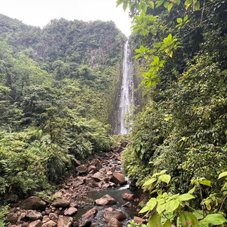
Hiking to the Second Carbet Waterfall in Guadeloupe
The Deuxième Chute du Carbet, 110 meters high, is one of the most impressive waterfalls in Guadeloupe. Located in the heart of the National Park, in the town of Capesterre-Belle-Eau, it is accessible via a very well-maintained path.
Access and Practical Information
To reach the starting point, from Pointe-à-Pitre, go around Capesterre-Belle-Eau on the ring road and continue to the Saint-Sauveur section. From there, take the D4 for about 8.5 km to the end of the road, where a roundabout near the reception area allows passengers to drop off before finding a parking space downstream.
Entrance to the site is charged at around €5 per person, which contributes to the maintenance of the trails by the National Park. Credit card payments are accepted.
The Path
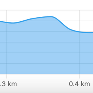
The trail to the Second Falls is well-maintained and marked, making the hike accessible to most visitors. The route, approximately 1.6 km round trip, has a low elevation gain, with an elevation ranging from 575 to 625 metres. The estimated duration of the walk is approximately 40 minutes round trip.
The trail passes through a tropical rainforest, offering views of lush vegetation including tree ferns and epiphytic plants. Features such as stone paving, non-slip mesh decking and protective barriers make progress easier on the steeper sections.
Points of Interest
Along the way, information panels provide details on the local fauna, flora and geology. A picnic area with carbets is available at the Chutes du Crabet reception for a lunch break. Toilets are also available.
As you approach the falls, a bridge crosses the Grand Carbet River, offering views of small waterfalls upstream and downstream. You arrive at a platform, located about 175 meters from the foot of the waterfall, offering a breathtaking view of the entire fall.
Advice to Visitors
Safety : Access to the foot of the waterfall is prohibited due to the risks associated with falling rocks and landslides. It is essential to respect this prohibition for your safety.
Equipment : Although the trail is groomed, non-slip footwear is recommended due to the wetness and potentially slippery sections.
Weather : Before setting off, check the weather conditions, as the trail can become slippery after rain.
Hours : It is advisable to start the hike early in the day to take advantage of the best light conditions and avoid the crowds.
Download the GPX Track of the Hike
For those who wish to explore the Deuxième Chute du Carbet independently, we offer a detailed GPX track of the hike, to be opened on an application such as maps.me
This hike is part of our exclusive pack: 16 must-see trails in Guadeloupe. Enjoy it!


Comments